
A History
In 1972 under the Project Clean Air contract (#PCA-038) an Aerosol Analysis System was designed, built, and utilized at Crocker Nuclear Laboratory, University of CA — Davis, in conjunction with the California Air Resources Board (ARB). The purpose of this novel system was to develop techniques in performing elemental analysis of atmospheric particulate samples using accelerator beams and resulted in the first light element detection of scattering accelerator beams for smog samples. The UCD-ARB joint effort began a state-level air quality monitoring and analysis network that would set precedent for future monitoring programs as well as grow over the years and merge into the national networks run today.
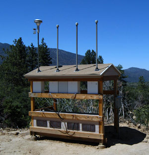
Five years after the initial contract, the Clean Air Act was enacted by Congress in 1977 with the goal of identifying the cause of regional haze and how to decrease visible pollution. With the Clean Air Act in legislation the Environmental Protection Agency (EPA) organized the Interagency Monitoring of Protected Visual Environments (IMPROVE) in 1985 — again with UC Davis. Aerosol researchers and engineers designed and deployed the first aerosol sampling stations, and 20 sites were in operation by 1987. As the network expanded so did the need for a cohesive, collaborative Air Quality group to develop and run analyses, as well as maintain and operate sites on a long-term scale. 2005 saw the inception of the Air Quality Research Center at UC Davis (AQRC).
Currently
AQRC maintains and operates two national networks, which monitors air quality across the country: CSN (Chemical Speciation Network, urban sites) and IMPROVE (rural sites). The map below shows monitoring locations for both national networks, plus collocated sites. The IMPROVE network includes monitoring stations in Canada and South Korea, in addition to its national locations.

Currently, the AQRC monitoring laboratory is equipped for efficient handling and analysis of the large volume of filters generated in both networks. All IMPROVE polytetrafluoroethylene (PTFE) filter analyses are performed on-site at UC Davis, including gravimetric mass, Energy Dispersive X-ray Fluorescence (EDXRF), and light absorption via hybrid integrating plate and sphere (HIPS) analysis.
UC Davis offers expertise in EDXRF of PM samples with extensive tests on PANalytical Epsilon 5 instruments to characterize them fully for elemental analysis of IMPROVE filters. In recent years, the AQRC lab group has produced EDXRF calibration standards that are (a) specially formulated for the low PM concentrations observed on IMPROVE samples, (b) produced by collecting known particle concentrations onto the filters used in the network, (c) prepared using the same samplers used to load these filters in the field, and (d) made with loadings similar to those observed on CSN filters.
While data generated by the aerosol samplers are primarily used to monitor long-term trends in visibility, others have made use of the wealth of information made available by IMPROVE for a variety of investigations. These include searching for the sources of emissions that are causing air pollution at specific sites, and correlating meteorological data with statistical models and maps of IMPROVE data to track the long-range movement of pollutants from large emitters such as power plants and refineries.